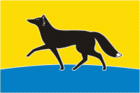
Surgut
 |
 |
The name of the city, according to one tradition, originates from the Khanty words sur 'fish' and gut 'hole, pit'. It was founded in 1594 by order of Tsar Feodor I.
Surgut at the end of the 16th century was a small fortress with two gates and five towers, one of which had a carriageway. In 1596 the Gostiny Dvor was built. In the 17th and 18th centuries it was a center of the Russian development of Siberia. The fortification, built of strong wood, was located on the cape, so that it was impossible to approach it unnoticed either from the river or from the land. In the central square of the ancient settlement there was a cult shrine. Along the perimeter, the fortress was surrounded by a moat, which was blocked by the structures of the defensive system. Outside the village there were special buildings - handicraft workshops, in particular, a smithy. By the name list of 1625 there were 222 servicemen living here. Subsequently, due to high mortality, the population of Surgut gradually decreased. In 1627 it was home to 216 people, which shrank to 200 in 1635, and 199 in 1642. In the second half of the 17th century the population fluctuated around 200 people, and by the end of the century there were 185 inhabitants in Surgut.
Since 1782, the county town of the Surgut district of the Tobolsk province had been formed. In 1785, the city's coat of arms was approved. At the end of the 18th century, in connection with the development of southern Siberian cities, it lost its administrative significance. Since 1868 - district, and since 1898 - the county town of Tobolsk province. The inhabitants of Surgut, like other Siberians, were on state security. Servants annually received money (5 rubles and 25 kopecks), bread (8 quarters for bachelors and 11 quarters for married couples) and salt (a pound and a quarter for bachelors and a pound and a half for married couples). The inhabitants were supplied with weapons and ammunition. At the end of the 19th century (according to the census of 1897), the population of Surgut was 1100 people. The main occupations of the inhabitants were fishing, gathering of wild plants, trade, cattle breeding, and firewood harvesting. In 1835 the Cossack school was founded, and in 1877 - the men's folk school. The women's parochial school also began operation, along with a weather station in 1878, the library-reading room, the people's house, and since 1913, the telegraph. Since November 3, 1923, the city has been the administrative center of the Tobolsk district of the Ural region. Since April 5, 1926, due to the small population of 1300, Surgut was transformed into a district village. In 1928, on the basis of the fish section, the first industrial enterprise was created - the fish canning factory. In 1929 a collective farm was organized, in 1930 - a forest site, and in 1931 - a timber enterprise. In the 1930s in Surgut, attempts were made to extract minerals. October 23, 1934 was the publication date of Surgut's first newspaper - the "Organizer" (today, the "Surgut Tribune").
Rapid urbanization of Surgut took place in the 1960s, when it became a center of oil and gas production. On June 25, 1965 the work settlement of Surgut was granted town status. The city's holiday is celebrated annually on June 12. The current mayor is Andrey Filatov (since 2021). Ex-mayor Alexander Sidorov oversaw the construction of the Surgut Bridge, the longest one-tower cable-stayed bridge in the world.
Map - Surgut
Map


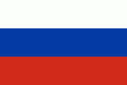
Country - Russia
 |
 |
| Flag of Russia | |
The East Slavs emerged as a recognisable group in Europe between the 3rd and 8th centuries CE. The first East Slavic state, Kievan Rus', arose in the 9th century, and in 988, it adopted Orthodox Christianity from the Byzantine Empire. Rus' ultimately disintegrated, with the Grand Duchy of Moscow growing to become the Tsardom of Russia. By the early 18th century, Russia had vastly expanded through conquest, annexation, and the efforts of Russian explorers, developing into the Russian Empire, which remains the third-largest empire in history. However, with the Russian Revolution in 1917, Russia's monarchic rule was abolished and replaced by the Russian SFSR—the world's first constitutionally socialist state. Following the Russian Civil War, the Russian SFSR established the Soviet Union (with three other Soviet republics), within which it was the largest and principal constituent. At the expense of millions of lives, the Soviet Union underwent rapid industrialization in the 1930s, and later played a decisive role for the Allies of World War II by leading large-scale efforts on the Eastern Front. With the onset of the Cold War, it competed with the United States for global ideological influence; the Soviet era of the 20th century saw some of the most significant Russian technological achievements, including the first human-made satellite and the first human expedition into outer space.
Currency / Language
| ISO | Currency | Symbol | Significant figures |
|---|---|---|---|
| RUB | Russian ruble | ₽ | 2 |
| ISO | Language |
|---|---|
| CE | Chechen language |
| CV | Chuvash language |
| KV | Komi language |
| RU | Russian language |
| TT | Tatar language |